This system makes full use of modern scientific and technological means to explore new teaching and training models. Under limited time and equipment guarantee conditions, students can quickly master basic surveying and mapping skills, improve teaching efficiency, reduce teacher labor intensity, and give full play to the laboratory role in teaching. The system includes a leveling indoor training and assessment module and a total station measurement training module, which can complete leveling station observation, handbook calculations, leveling route adjustment calculation training and assessment, total station angle observation, handbook calculations and terrain points. Data collection process training.
1. Leveling indoor training and assessment module
1. Implement functions
The core of the system is a computer-controlled precision ruler driving platform, which allows the ruler to rise and fall to simulate actual level measurement ground fluctuations. Level measurement training and assessment can be achieved in the laboratory through supporting software. The main functions are:
(1) Able to complete second-, third-, and fourth-level route measurement and adjustment simulation training and assessment;
(2) It has three modes: instrument operation reading, route measurement training and route measurement and adjustment assessment;
(3) It has real-time guidance and error prompt functions in training mode;
(4) The measurement data and route adjustment calculation results are automatically formed into a WORD format table document (handbook);
(5) Up to 4 groups of 5 people each can be trained and assessed at the same time;
(6) The assessment data is automatically uploaded to the teacher’s computer, and the system automatically checks the observation and calculation data and provides reference data for evaluation;
(7) The ruler is replaceable and can be adapted to a variety of instruments.
(8) The small local area network built through WIFI has stable and reliable data communication and is easy to deploy. The teacher's computer can view the operation status of each student in real time.
2. Main features
(1) The basic operation of the level, leveling line measurement training and automatic assessment are realized, and the correctness of the observation results is checked and evaluated in real time.
(2) Suitable for training with various brands of optical and digital levels, and the instruments and rulers can be replaced.
(3) It is a new experimental teaching model that is the first in China to realize level measurement training that could only be done outdoors in the past in the laboratory.
(4) It combines the convenience of simulation learning software with the reality of actual outdoor training to create an efficient and practical leveling training method.
3.Hardware composition
It is mainly composed of a main control computer (teacher machine), a WIFI router, a tablet terminal (student machine), a level (electronic or optical), and a precision ruler driving platform.
Leveling indoor training and assessment module equipment and parameters |
name | Functional parameters or requirements | quantity | unit |
DSxy3401 precision scale drive platform | 1. Consists of a stable base frame, precision screw, electronic control drive device and scale base plate. Height 1750mm , weight about 50kg . 2. The displacement accuracy is better than 5 μm , which can meet the accuracy requirements of level 2 to 4 . 3.220V AC power supply, RS485 data interface, and good data transmission reliability. | 1 | right |
ruler | The special Kiev scale is divided into the same plane and can be customized and replaced according to the instrument used and the measurement level. Length 900mm~1200mm customized according to site height difference. | 1 | right |
Main control machine | Desktop computer, Win7/8 /10 operating system, memory ≥4G, hard disk ≥128G. | 1 | tower |
terminal | Tablet computer, Win7/8 /10 operating system , memory ≥4G, hard disk ≥64G. | 5 | tower |
router | Ordinary WIFI router | 1 | tower |
Instrument feet | Made of metal, the three support arms are at 120 °, with an arm length of 80cm, a width of 5cm, and a thickness of 5mm . There is a round hole in the middle to show the ground point mark. Each arm is engraved with three concave points spaced 10cm apart for placing the tripod, which is strong and stable. | 10 | indivual |
Level | Various types of electronic or optical levels can be used. It can be selected based on the existing teaching equipment and is not included in the equipment provided by this system. | 5 | tower |
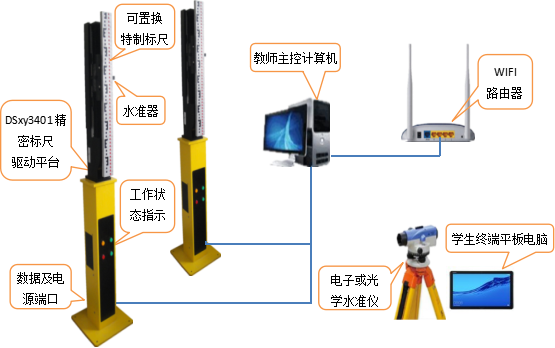
Figure 1 Equipment deployment diagram
4. Supporting software
Leveling indoor training and assessment module software and functions |
name | Functional parameters or requirements | quantity | unit |
Teacher computer software SZXLT2.0 | (1) Setting of training mode, level, time of each station and other parameters; (2) Real-time viewing of the status of each student machine, such as network connection, data submission status, observation progress, etc.; (3) Control the start and end of training, send training status messages to student computers, and receive data from student computers; (4) Automatically design the horizontal route and control the movement of the lifting device; (5) Check the assessment data uploaded by students' computers and generate assessment reports. | 1 | set |
Student computer software SZXLS2.0 | (1) Record entry of observation data and calculation data; (2) Receive the training status message sent by the teacher machine; (3) Upload training or assessment observation data and results to the teacher’s computer; (4) Parameter settings such as self-service training mode, parameters, start and stop; (5) Generate training observation data handbook in this machine. | 1 | set |
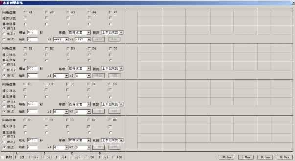
Figure 2 Teacher computer software
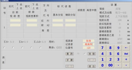
Figure 3 Student computer software
2. Total station measurement training module
1. Implement functions
1. Complete the angle (horizontal and vertical angle) observation training of the total station by observing the observation signs set on the wall or outdoors (visible through windows) in the laboratory. The observation data are transmitted to the teacher's computer in real time and projected by the projector. Instrument display, training system real-time discrimination of various tolerance indicators, real-time prompts for issues such as exceeding limits. Thus, the use of total station and angle measurement skill training can be realized efficiently and quickly.
2. Use the laboratory terrain model to realize indoor training of topographic survey. The method, process and correctness of topographic survey can be checked in real time, and errors and errors in station setting, orientation and topographic point collection can be prompted in real time.
2. Equipment
It mainly includes teacher computers, WIFI routers, projectors, and the specially developed RTS302R10W total station with built-in training functions.
Total station measurement training module equipment and parameters |
name | Functional parameters or requirements | quantity | unit |
RTS302R10W total station | Distance measurement accuracy: ± (2mm + 2 × 10⁻⁶ · D) Angle measurement method: absolute encoding Angle measurement accuracy: 2 ″, minimum reading 1 ″ Compensator: biaxial compensation, compensation range: ± 3 ′, compensation accuracy 1 ″ Power supply: 7.4V rechargeable lithium-ion battery, working time ≥ 12 hours Communication: RS-232C/USB/WIFI Memory: 120,000 points, hot-swappable SD card can be installed Others: laser point-to-point, prism-free distance measurement. | 10 | tower |
Main control machine | Desktop computer, Win7/8 /10 operating system, memory ≥4G, hard disk ≥128G. (Can be used in conjunction with the leveling training module) | 1 | tower |
router | Ordinary WIFI router (can be used in conjunction with the leveling training module) | 1 | tower |
Instrument feet | Made of metal, the three support arms are at 120 °, with an arm length of 80cm, a width of 5cm, and a thickness of 5mm . There is a round hole in the middle to show the ground point mark. Each arm is engraved with three concave points spaced 10cm apart for placing the tripod, which is strong and stable. (Can be used in conjunction with the leveling training module) | 10 | indivual |
Projector | Image ≥ 20,000 lumens; resolution ≥ 1920 × 1080 ; global contrast ratio 2100 : 1 ~ 2700 : 1 , screen ratio 16:9 ; video input includes VGA , RGB , HDMI , DVI . Light source ≥ 3KW , life ≥ 1000h . Configure installation accessories and cables according to laboratory conditions. (not included in system supply) | 1 | tower |
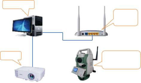
Figure 4 Schematic diagram of equipment deployment
3. Supporting software
Total station measurement training module software and functions |
name | Functional parameters or requirements | quantity | unit |
Teacher computer software | ( 1 ) Complete horizontal and vertical angle observation training. Based on the existing terrain sand table, complete the total station terrain data collection training. ( 2 ) Measurement training of 10 total stations can be carried out at the same time. ( 3 ) The horizontal angle can be used for full-circle direction angle measurement training with 1 to 4 measurements in 2 to 4 directions . The vertical angle can be used for observation training of the middle wire method with 1 to 2 measurements in 1 to 4 directions . ( 4 ) The zero return difference, the mutual difference between horizontal direction measurement returns, the mutual difference between index differences and the mutual difference between vertical angle measurement returns can be set according to training requirements. ( 5 ) It has the function of automatic judgment of the limit difference and provides real-time prompts during training. ( 6 ) The observation data display of multiple instruments can be automatically switched or manually switched. ( 7 ) Observation training data can be stored as a WORD file in the table format of the handbook . ( 8 ) Automatically generate an observation quality report to make statistics on the number of exceedances, number of remeasurements, observation accuracy, and extreme values of tolerance items. | 1 | set |
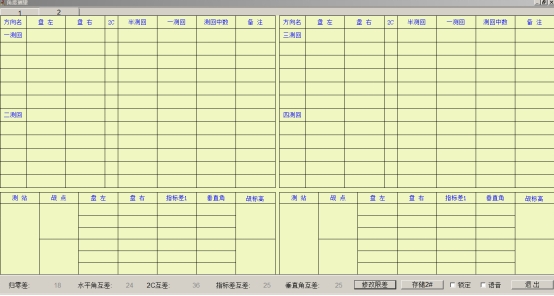
Figure 5 software interface
3. Laboratory space requirements
The recommended site area is no less than 200m 2 . The figure below shows a typical equipment layout.
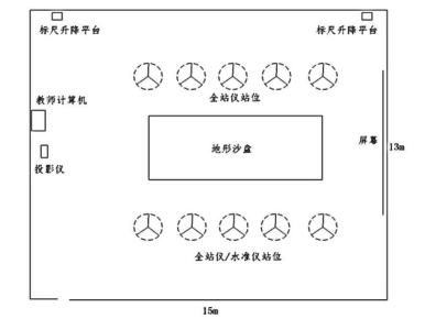
Figure 6 Typical equipment layout diagram